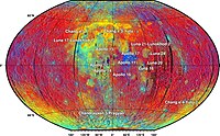
Photo from wikipedia
High-frequency lunar penetrating radar (LPR) data from an instrument on the lunar rover Yutu, from the Chang'E-3 (CE-3) robotic lander, were used to build a three-dimensional (3-D) geological model of… Click to show full abstract
High-frequency lunar penetrating radar (LPR) data from an instrument on the lunar rover Yutu, from the Chang'E-3 (CE-3) robotic lander, were used to build a three-dimensional (3-D) geological model of the lunar subsurface structure. The CE-3 landing site is in the northern Mare Imbrium. More than five significant reflection horizons are evident in the LPR profile, which we interpret as different period lava flow sequences deposited on the lunar surface. The most probable directions of these flows were inferred from layer depths, thicknesses, and other geological information. Moreover, the apparent Imbrian paleoregolith homogeneity in the profile supports the suggestion of a quiescent period of lunar surface evolution. Similar subsurface structures are found at the NASA Apollo landing sites, indicating that the cause and time of formation of the imaged phenomena may be similar between the two distant regions.
Journal Title: Geophysical Research Letters
Year Published: 2017
Link to full text (if available)
Share on Social Media: Sign Up to like & get
recommendations!