Photo from wikipedia
The positive and negative terrains (P-N terrains) widely distributed across China’s Loess Plateau constitute the dual structure characteristic of loess landforms. Analysis of loess P-N terrains at the watershed scale… Click to show full abstract
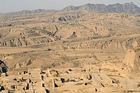
The positive and negative terrains (P-N terrains) widely distributed across China’s Loess Plateau constitute the dual structure characteristic of loess landforms. Analysis of loess P-N terrains at the watershed scale can serve to elucidate the structural characteristics and spatial patterns of P-N terrains, which benefits a better understanding of watershed evolution and suitable scales for loess landform research. The Two-Term Local Quadrat Variance Analysis (TTLQV) is calculated as the average of the square of the difference between the block totals of all possible adjacent pairs of block size, which can be used to detect both the scale and the intensity of landscape patches (e.g., plant/animal communities and gully networks). In this study, we determined the latitudinal and longitudinal spatial scale of P-N terrain patterns within 104 uniformly distributed watersheds in our target soil and water conservation region. The results showed that TTLQV is very effective for examining the scale of P-N terrain patterns. There were apparently three types of P-N terrain pattern in latitudinal direction (i.e., Loess Tableland type, Loess Hill type, and Transitional Form between Sand and Loess type), whereas there were both lower and higher values for P-N terrain pattern scales in all loess landforms in the longitudinal direction. The P-N terrain pattern also clearly presented anisotropy, suggesting that gully networks in the main direction were well-developed while others were relatively undeveloped. In addition, the relationships between the first scales and controlling factors (i.e., gully density, nibble degree, watershed area, mean watershed slope, NDVI, precipitation, loess thickness, and loess landforms) revealed that the first scales are primarily controlled by watershed area and loess landforms. This may indicate that the current spatial pattern of P-N terrains is characterized by internal force. In selecting suitable study areas in China’ Loess Plateau, it is crucial to understand four control variables: the spatial scale of the P-N terrain pattern, the watershed area, the main direction of the watershed, and the loess landforms.
Journal Title: Journal of Mountain Science
Year Published: 2017
Link to full text (if available)
Share on Social Media: Sign Up to like & get
recommendations!