Photo from wikipedia
Abstract Lake Victoria's surface area has recently been shown to have shrunk by 0.3 % compared to its 1984 value, a decline that has been associated with climatic as well… Click to show full abstract
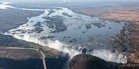
Abstract Lake Victoria's surface area has recently been shown to have shrunk by 0.3 % compared to its 1984 value, a decline that has been associated with climatic as well as anthropogenic factors. Climatic factors include, e.g., reduced rainfall, which impacts not only on the lake's water level but also on the basin's vegetation that forms the lake's catchment. Understanding the locations of vegetation changes and the driving forces of such changes, therefore, is of most critical importance to major stakeholders regarding environmental management, policies and planning. For Lake Victoria Basin (LVB; Kenya, Uganda, Tanzania, Rwanda and Burundi), human development and climatic variability/change have subjected the region to significant changes in its vegetation characteristics whose spatio-temporal patterns are, however, not well understood. To understand this variability in vegetation for the period 2003–2018, this study employs the use of remotely sensed MODIS (Moderate Resolution Imaging Spectroradiometer), CHIRPS (Climate Hazards Group InfraRed Precipitation with station data) precipitation data, Google Earth Pro imagery, Gravity Recovery and Climate Experiment (GRACE)-based Mascon's total water storage (TWS) products and the statistical PCA (Principal Component Analysis). The study aims at determining (i) ‘‘significant hotspots’’, i.e. vegetation areas within the LVB largely impacted, and (ii), the extent of which anthropogenic and climatic variability have contributed to the ‘‘hotspots’’ formation. The results indicate a total of 8 hotspots; 5 in Uganda and 1 each in Kenya, Tanzania and Rwanda. Google Earth Pro imagery of all the hotspots show the changes in anthropogenic processes as the primary driver for the long-term changes in vegetation characteristics. Conversely, the analysis of PCA and Mascon's TWS concluded that only the Tanzanian hotspot may have been driven somewhat by climate variability. Climate variability is understood to be the driver of short-term vegetation changes while the long-term effects are driven primarily by human influence.
Journal Title: Applied Geography
Year Published: 2020
Link to full text (if available)
Share on Social Media: Sign Up to like & get
recommendations!