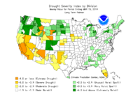
Photo from wikipedia
Abstract As the most frequent and longest-lasting climate-related disasters, droughts are complex processes caused by hydrological imbalance, and have significant effects on ecosystem function and socioeconomic development. However, most conventional… Click to show full abstract
Abstract As the most frequent and longest-lasting climate-related disasters, droughts are complex processes caused by hydrological imbalance, and have significant effects on ecosystem function and socioeconomic development. However, most conventional satellite-based drought indices and combined drought indices are mechanically constrained by the fact that they were developed and evaluated for a specific climate or critical ecological region, especially in China. A comprehensive drought index should be developed for extensive application in different climate-hydrology regions. To address this problem, an optimised principal component analysis method (PCA-RF) was proposed to support drought assessment across the transitional area between the humid and arid regions in central China, including the Loess Plateau (LP) and Qinling Mountains (QL). This method eliminated the causal relationships of non-linear changes for multi-aspect parameters such as land surface temperature, precipitation and soil moisture, and was used in developing a new index named “Meteorological drought index by PCA-RF methods (PMDI)”. The results showed that PMDI had higher correlations and lower root mean square error than other drought indices (established using the empirical-weights method) with the 1-month standardized precipitation evapotranspiration index (SPEI-1). That means PMDI performed well in meteorological drought monitoring. Additionally, the normalized difference vegetation index (NDVI) and solar-induced chlorophyll fluorescence (SIF) were utilised to evaluate PMDI effectiveness in detecting vegetation response to drought, which represents agricultural drought. The results indicated that correlations between PMDI and vegetation indices (VIs) were stronger when severe or extreme droughts occurred, and that their relationships were affected by the high spatiotemporal heterogeneity in vegetation change over the LP and QL. Overall, PMDI was shown here to be a very suitable index for monitoring meteorological drought (short-term) and has effective action in capturing the response of vegetation signals to agriculture drought events (long-term). Given the excellent performance of PMDI in diverse climate-hydrology conditions of our study regions, we concluded that the PMDI has considerable potential as a drought monitoring methodology on a larger spatial scale.
Journal Title: Atmospheric Research
Year Published: 2021
Link to full text (if available)
Share on Social Media: Sign Up to like & get
recommendations!