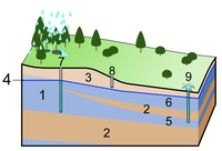
Photo from wikipedia
The increasing demand for water occasioned by harsh climatic conditions, population explosion, and increasing urbanization has necessitated more attention and reliance on groundwater resources, particularly in water-limited regions. Thus, judicious… Click to show full abstract
The increasing demand for water occasioned by harsh climatic conditions, population explosion, and increasing urbanization has necessitated more attention and reliance on groundwater resources, particularly in water-limited regions. Thus, judicious management of available groundwater resources becomes crucial to meet the freshwater requirements in such zones. In this study, remote sensing and geographic information system were deployed to delineate groundwater recharge zones in semi-arid geological transition zones of Bauchi, northeastern Nigeria. Seven thematic layers comprising elevation, slope, land use/land cover, drainage density, lithology, magnetic lineament density, and hydraulic head were integrated based on their degree of influence in groundwater recharge. Normalization of the weights was achieved through the analytical hierarchical process (AHP), while the overall integration of the thematic maps was actualized by overlay analysis in ArcGIS 10.3.1 environment to generate a final groundwater recharge zone map of the area. The resulting map was delineated into three different zones: low, moderate, and high, occupying 20% (627 km2), 77% (2352 km2), and 3% (80 km2) respectively. The overall assessment of recharge zones revealed that a high percentage of the southwestern part of the study are characterized dominantly by poor groundwater recharge potential, attributable to high elevations and impervious rock outcrops with associated steep slopes, thus limited infiltration owing to the high velocity of runoff. The northwestern and parts of the southwestern zones, underlain by migmatite/gneiss, and partly granites, however, exhibited medium-low recharge potential, owing to the occurrence of considerably lower altitudes and occupied by thicker regoliths and underlying rocks of medium-high lineament densities. The sandstones revealed predominantly medium-high recharge potential, attributable to high permeability, lower hydraulic heads, and relatively flat geomorphology which enhances meteoric recharge and base flow processes.
Journal Title: Heliyon
Year Published: 2021
Link to full text (if available)
Share on Social Media: Sign Up to like & get
recommendations!