Photo from wikipedia
Abstract In this study we address the question of whether the Tharsis rise that occupies ~25 % of the surface area of Mars was once covered by an ice cap,… Click to show full abstract
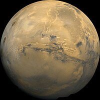
Abstract In this study we address the question of whether the Tharsis rise that occupies ~25 % of the surface area of Mars was once covered by an ice cap, and the sudden ice-cap melting was responsible for the catastrophic development of the Late Hesperian (3.5-3.6 Ga) circum-Tharsis giant (>1000s km in length) outflow channels. To achieve this goal, we conducted geomorphologic mapping across the Oudemans crater basin (~125 km in diameter) at elevations of ~2.7 km to ~5.0 km and its bounding plateau plains at elevations of ~5.3 km to ~6.7 km in the central Tharsis rise. Our work shows that the Oudemans-impact-induced landforms were superposed by a suite of younger landform assemblages, which consist of horn-like peaks, arete-like ridges, cirque-like depressions, hanging-valley-like features, trim-line-like escarpments, lobate ridges, striated, pitted and hummocky terrains, and features resembling drumlins, crag-and-tails and roches moutonnees. A plateau-plain striated terrain on a hummocky surface exhibits streamlined linear ridges that are 400-2000 m wide and up to ~17 km long. The average length-width ratio (~9), shape, surface texture, and associated washboard landform pattern of the linear morphological features in the striated terrain on Mars are comparable to mega-scale glacial lineations (MSGLs) on Earth. Using well-understood Earth analogues as a guide, we interpret the post-Oudemans-impact landform assemblages to have formed during regional ice-sheet-style glaciation. We further suggest the striated terrain on the plateau plains to have been generated by a fast-moving ice stream in a regional ice sheet that filled 4-km deep Oudemans crater and covered the crater-bounding plateau plains in the central Tharsis rise. The volume of the glacier ice stored in the Oudemans crater basin alone is estimated on the order of ~200,000 km3. The shape of the inferred glacier-induced landforms and their cross-cutting relationships require early northward-flowing northward-advancing glaciation, followed by southward-flowing northward-retreating glaciation. The size-frequency distribution of the craters superposed on top of the interpreted glaciated landforms in the mapped area yields a glaciation age of ca. 3.5 Ga, coeval with the estimated age of the interpreted glacial landforms along the 2000-km long Valles Marineris trough zone east of the study area. The inferred glaciation age is also coeval with the development of the circum-Tharsis outflow channels. Although our work supports the Tharsis ice-cap hypothesis, the full extent of the ice cap within and possibly beyond the Tharsis rise remains unconstrained.
Journal Title: Icarus
Year Published: 2021
Link to full text (if available)
Share on Social Media: Sign Up to like & get
recommendations!