Photo from wikipedia
Abstract Three major Maya centers recently discovered in the northern part of the uninhabited Calakmul Biosphere Reserve in eastern Campeche, Mexico, provided the first archaeological information obtained in an extensive,… Click to show full abstract
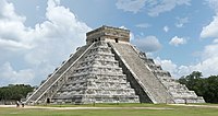
Abstract Three major Maya centers recently discovered in the northern part of the uninhabited Calakmul Biosphere Reserve in eastern Campeche, Mexico, provided the first archaeological information obtained in an extensive, formerly unexplored area in the central lowlands of the Yucatan peninsula. Based on ALS (lidar) data, which were acquired for a broader area of 230 km2 and revealed a thoroughly modified and undisturbed archaeological landscape, and on additional information provided by subsequent field surveys and test excavations, we focus on the techniques of water management and agricultural intensification reflected in specific types of landscape modifications. By analyzing their characteristics, distribution and chronology, we discuss their practical functions, which in the region characterized by the lack of permanent water sources were of foremost importance, and further infer the sociopolitical structures involved in their construction and maintenance. We also interpret the significance of these features in Maya worldview and ritual and their role in landscape construction and conceptualization, and show their potential for addressing other fundamental questions of archaeological relevance, including population estimates, settlement dynamics, and the processes that led to the final demise of Classic Maya culture in the central lowlands.
Journal Title: Journal of Anthropological Archaeology
Year Published: 2021
Link to full text (if available)
Share on Social Media: Sign Up to like & get
recommendations!