Photo from wikipedia
Abstract The measured orientation of geological surfaces such as bedding or fracture planes varies with scale of observation. This can be demonstrated by comparing representative orientation of an outcropping surface… Click to show full abstract
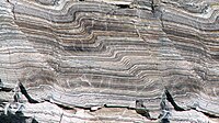
Abstract The measured orientation of geological surfaces such as bedding or fracture planes varies with scale of observation. This can be demonstrated by comparing representative orientation of an outcropping surface at centimeter, decameter and kilometer scale. It can also be verified by tracking variation of dip vectors while generalizing structure maps of subsurface horizons stored as numeric grids. The challenge of obtaining meaningful orientation information from outcrops is well-known but in practice, field geologists intuitively extract orientation information that suits their purposes rather than explicitly recording the scale of observation or even measurement process. There is an analogous problem when subsurface structural maps in sedimentary basins, made from kilometer-scale areas of reflection seismic interpretation, are integrated with wells containing image logs that yield strike and dip information at a scale of tens of centimeters. In the absence of upscaling guidelines, maps are often tied to the correct depth, but not to the structural orientation measured in piercing wells. The solution at outcrop and wells is to explicitly determine the scale-dependent structure, then use information at the appropriate length scale as required. Complete description of strike and dip requires a length scale parameter in addition to the orientation values.
Journal Title: Journal of Structural Geology
Year Published: 2020
Link to full text (if available)
Share on Social Media: Sign Up to like & get
recommendations!