Photo from wikipedia
Abstract Rockfall geological disasters and shockwave-induced disasters in underground stopes are normally observed due to overburdened strata movement and surface subsidence of a goaf area, that is normally huge, and… Click to show full abstract
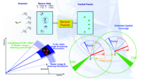
Abstract Rockfall geological disasters and shockwave-induced disasters in underground stopes are normally observed due to overburdened strata movement and surface subsidence of a goaf area, that is normally huge, and of complex shape, in underground mines. Safety monitoring is an effective approach for predicting such disasters before the goafs have been completed. A multi-sensor real-time on-line monitoring and warning system was established using computer technology, stress monitoring technology, and Zigbee wireless network communication technology. The proposed monitoring system consists of four main units: a stress monitoring unit, a data acquisition unit, a wireless communication unit, and a database management unit. A two-phase multi-source spatial-temporal information fusion model was proposed, which uses continuous data series context from sensors to evaluate changing the corresponding stress around the goaf areas. Meanwhile, the proposed method also uses redundant information from different sensors to derive spatial connections, and allow data fusion, therewith. To demonstrate the proposed methodology, the proposed system was applied to Mine A, which has many goafs, and effective data were acquired after two years of continuous monitoring. Furthermore, monitored data were fused using the proposed two-phase spatial-temporal fusion model. A three-dimensional stress contour map of the goafs was drawn, which made the stress changes more intuitive and accurate. More importantly, it can provide short-time warning information about stability and can serve as a scientific basis for predicting geological disasters caused by goafs.
Journal Title: Tunnelling and Underground Space Technology
Year Published: 2019
Link to full text (if available)
Share on Social Media: Sign Up to like & get
recommendations!