Photo from wikipedia
Mobile, polarimetric radar data were collected on a series of tornadoes that occurred near Dodge City, Kansas. A poststorm survey revealed a series of tornadic debris swaths in several dirt… Click to show full abstract
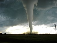
Mobile, polarimetric radar data were collected on a series of tornadoes that occurred near Dodge City, Kansas. A poststorm survey revealed a series of tornadic debris swaths in several dirt fields and high-resolution pictures of the tornado documented the visual characteristics of the tornado and the lofted debris cloud. The main rotational couplet associated with the tornado was identified in the single-Doppler velocities; however, no secondary rotational couplets were resolved in the low-level data performed during two consecutive volume scans. Numerical simulations have suggested that cycloidal damage swaths can result when debris is deposited as the low-level inflow turns upward in the corner region of the updraft annulus of the tornado core. This mechanism can dominate even when suction vortices are present in the simulations and can produce these swaths in the absence of these smaller-scale vortices. It is hypothesized that the observed cycloidal damage swaths were a result of the low-level inflow in the corner region of the tornado and not by the existence of suction vortices. Polarimetric data were combined with photographs of the tornado in order to document the lofted debris cloud and its relationship with the funnel. This analysis provided an opportunity to investigate whether recent findings describing the cross-correlation coefficient ρhv and differential reflectivity ZDR signatures of the lofted debris cloud could be replicated. Regions of low ρhv at the periphery of the funnel cloud suggesting high debris loading and a column of negative ZDR centered on the tornado believed to be produced by common debris alignment were noted. It is well known that some tornadoes produce smaller-scale vortices that rotate around the central axis of the main circulation. In addition, numerous aerial photographs have documented cycloidal debris marks within tornado damage tracks that traverse open fields. The prevailing theory shown in numerous textbooks is that these marks are produced by these vortices. The current study suggests that this widely accepted model for producing these marks may be incorrect. It is suggested that these cycloidal marks are produced by the main tornado circulation and not by the smaller-scale vortices in this case.
Journal Title: Monthly Weather Review
Year Published: 2022
Link to full text (if available)
Share on Social Media: Sign Up to like & get
recommendations!