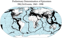
Photo from wikipedia
Assessments of megathrust earthquake rupture patterns provide fundamental insights into the processes that control the seismic cycle along subduction zones. When large earthquakes occur in regions with sparse geodetic networks,… Click to show full abstract
Assessments of megathrust earthquake rupture patterns provide fundamental insights into the processes that control the seismic cycle along subduction zones. When large earthquakes occur in regions with sparse geodetic networks, as was the case for the magnitude ( Mw ) 7.6 Chiloe, Chile, earthquake of 25 December 2016, estimates of vertical coseismic deformation from fixed intertidal biotic indicators provide important evidence that help to constrain fault slip. Ten months after the Chiloe earthquake, we observed a white fringe of bleached coralline algae (Corallinaceae) along the southeastern coastline of Isla Quilan, south of Isla de Chiloe, killed by reduced tidal wetting resulting from coseismic land uplift. Our quantitative measurements of the vertical extent of algal mortality provide the first field‐based report of the effects of the 2016 earthquake. We infer Isla Quilan coseismically uplifted by 25.8±14.3 cm . The vertical extent of mortality (VEM) and the aspect (compass direction) of the bedrock surface are uncorrelated, but we find that exposure to waves and shielding from insolation may prevent or delay mortality. Focusing on sites sheltered from waves, we demonstrate that with a large number of measurements ( >100 ), land‐level changes as low as 25 cm may be quantitatively assessed. The absence of bleaching on Isla de Chiloe may reflect the smaller magnitude of coseismic uplift at this location or the lack of suitably sheltered bedrock surfaces. Previously published fault dislocation models are consistent with our field observations; however, the coralline algae data are on their own insufficient to discriminate between competing hypotheses over the amount of fault slip. By combining our field data with space geodetic data in a model that uses detailed fault geometry, we constrain peak slip to ∼3 m , approximately 80% of the maximum cumulative plate convergence since the last great earthquake in the region.
Journal Title: Bulletin of the Seismological Society of America
Year Published: 2018
Link to full text (if available)
Share on Social Media: Sign Up to like & get
recommendations!