
Psychogeography as Embodied Connection to Place.
Sign Up to like & getrecommendations! Published in 2025 at "AMA journal of ethics"
DOI: 10.1001/amajethics.2025.402
Abstract: This article introduces psychogeography as a research method that relies on embodied practices of drifting (dérive) through a city, which are followed by subsequent creative cartography. Mapping and documentation that follow dérive promote fuller understanding… read more here.
Keywords: psychogeography embodied; connection place; chirp; cartography ... See more keywords
Error in Abstract.
Sign Up to like & getrecommendations! Published in 2019 at "JAMA surgery"
DOI: 10.1001/jamasurg.2019.2035
Abstract: In the Original Investigation titled “Patient Characteristics Associated With Telemedicine Access for Primary and Specialty Ambulatory Care During the COVID-19 Pandemic,”1 published December 29, 2020, there was an error in the Results paragraph of the… read more here.
Keywords: error; error abstract; cartography;
Cartography of SARS‐CoV‐2 variants based on the susceptibility to therapeutic monoclonal antibodies
Sign Up to like & getrecommendations! Published in 2022 at "Journal of Medical Virology"
DOI: 10.1002/jmv.28275
Abstract: A comprehensive picture of a phenotypic relationship among severe acute respiratory syndrome coronavirus 2 (SARS‐CoV‐2) variants has been poorly studied. Here, this study presents cartography showing how the wild‐type strain of SARS‐CoV‐2 and 14 variants… read more here.
Keywords: cov variants; therapeutic monoclonal; susceptibility therapeutic; cartography ... See more keywords
Atomic Cartography of High-Entropy Cs2BCl6 Perovskite-Inspired Materials: The Vital Role of Solid-State NMR Spectroscopy in Identifying Elemental Disorder.
Sign Up to like & getrecommendations! Published in 2025 at "Small methods"
DOI: 10.1002/smtd.202501044
Abstract: The burgeoning field of high‐entropy materials (HEMs) has sparked significant interest by leveraging synergistic “cocktail effects” from inexpensive and abundant elements to access unprecedented physical, optical, and chemical properties. While standard characterization techniques, such as… read more here.
Keywords: spectroscopy; perovskite inspired; nmr spectroscopy; cartography ... See more keywords

A new spatial spherical pattern model into interactive cartography pattern: multi-dimensional data via geostrategic cluster
Sign Up to like & getrecommendations! Published in 2022 at "Multimedia Tools and Applications"
DOI: 10.1007/s11042-021-11339-4
Abstract: A growing amount of research conducted in digital, cooperative with advances in Artificial Intelligence, Computer Vision including Machine learning, has managed to the advance of progressive techniques that aim to detect and process affective information… read more here.
Keywords: cartography; new spatial; pattern; model ... See more keywords
High-resolution geological cartography and coastal evolution assessment at Armação de Pêra – Galé sector: a prototype for a national coastal mapping
Sign Up to like & getrecommendations! Published in 2018 at "Journal of Coastal Conservation"
DOI: 10.1007/s11852-018-0612-2
Abstract: Portuguese coastal areas are of current major concern due to the continuous expansion of a strong urbanization, accentuated development of economic activities, resilient land use and general population growth. A particular attention has been given… read more here.
Keywords: resolution; mapping; evolution; cartography ... See more keywords
Network cartography of university students’ knowledge landscapes about the history of science: landmarks and thematic communities
Sign Up to like & getrecommendations! Published in 2019 at "Applied Network Science"
DOI: 10.1007/s41109-019-0113-8
Abstract: We examine students’ representations of their conceptions of the interlinked nature of science history and general history, as well as cultural history. Such knowledge landscapes of the history of science are explored by using the… read more here.
Keywords: network; cartography; science; knowledge landscapes ... See more keywords
Dynamical cartography of Earth satellite orbits
Sign Up to like & getrecommendations! Published in 2019 at "Advances in Space Research"
DOI: 10.1016/j.asr.2018.09.004
Abstract: Abstract We have carried out a numerical investigation of the coupled gravitational and non-gravitational perturbations acting on Earth satellite orbits in an extensive grid, covering the whole circumterrestrial space, using an appropriately modified version of… read more here.
Keywords: earth satellite; space; satellite orbits; cartography ... See more keywords
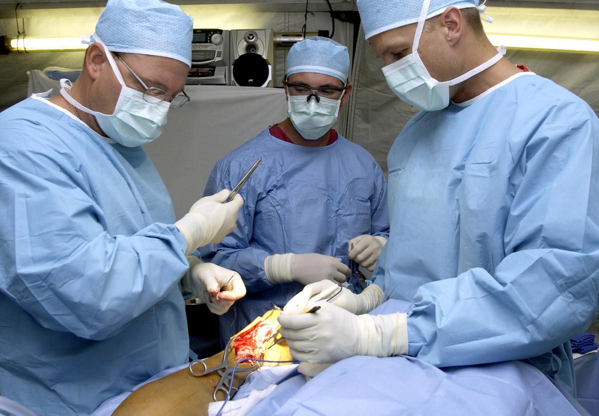
[OA195] Dosimetric evaluation of the O-arm® imaging system
Sign Up to like & getrecommendations! Published in 2018 at "Physica Medica"
DOI: 10.1016/j.ejmp.2018.06.267
Abstract: Purpose Three-dimensional (3D) imaging devices are emerging in operating theatres for intra-operative applications. Although there are reported benefits of this technology, such as increased surgical accuracy and higher patient safety, radiation exposure of staff and… read more here.
Keywords: arm imaging; cartography; exposure; arm ... See more keywords

Cosmo-SkyMed and TerraSAR-X datasets for geomorphological mapping in the eastern of Marajó Island, Amazon coast
Sign Up to like & getrecommendations! Published in 2020 at "Geomorphology"
DOI: 10.1016/j.geomorph.2019.106934
Abstract: Abstract The Amazon coast is marked by the high discharge of sediments and freshwater, macrotidal influence, a wide continental shelf, extensive flood plains and lowered plateaus which make it unique as a delta and estuary… read more here.
Keywords: coast; amazon coast; cosmo skymed; cartography ... See more keywords
Breaking up is hard to do: Global cartography and topography of Pluto's mid-sized icy Moon Charon from New Horizons
Sign Up to like & getrecommendations! Published in 2018 at "Icarus"
DOI: 10.1016/j.icarus.2018.06.010
Abstract: Abstract The 2015 New Horizons flyby through the Pluto system produced the first high-resolution topographic maps of Pluto and Charon, the most distant objects so mapped. Global integrated mosaics of the illuminated surface of Pluto's… read more here.
Keywords: topography; new horizons; cartography; pluto ... See more keywords