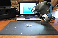
Open‐source terrestrial laser scanner for the virtualization of geometrical entities in AEC classrooms
Sign Up to like & getrecommendations! Published in 2022 at "Computer Applications in Engineering Education"
DOI: 10.1002/cae.22499
Abstract: This paper depicts a case study that shows an open‐source Terrestrial Laser Scanner (TLS) for use on the virtualization of simple yet precise geometrical entities in AEC classrooms. For bringing this technology to AEC classrooms,… read more here.
Keywords: aec classrooms; laser scanner; terrestrial laser; source terrestrial ... See more keywords

Using the terrestrial laser scanner and simple methodologies for geometrically assessing complex masonry vaults
Sign Up to like & getrecommendations! Published in 2019 at "Journal of Cultural Heritage"
DOI: 10.1016/j.culher.2018.10.003
Abstract: Abstract In recent years, the development of massive data capture techniques, such as the Terrestrial Laser Scanner (TLS), has raised the possibility of developing new procedures for assessing architectural heritage. The 3D models that can… read more here.
Keywords: masonry vaults; terrestrial laser; laser scanner; methodology ... See more keywords

PSD – probabilistic algorithm for mobile robot 6D localization without natural and artificial landmarks based on 2.5D map and a new type of laser scanner in GPS-denied scenarios
Sign Up to like & getrecommendations! Published in 2020 at "Mechatronics"
DOI: 10.1016/j.mechatronics.2019.102308
Abstract: Abstract This paper presents an approach to mobile robot 6D localization based on a 3D laser scanner in GPS-denied scenarios. Commonly, 6D localization using laser scanners is performed with the use of extraction and association… read more here.
Keywords: laser; robot; laser scanner; mobile robot ... See more keywords

Two points registration algorithm for terrestrial laser scanner point clouds
Sign Up to like & getrecommendations! Published in 2019 at "Survey Review"
DOI: 10.1080/00396265.2017.1418787
Abstract: Despite all modern techniques in registering terrestrial laser scanner point clouds, registration of multiple scan positions is still a crucial issue, especially in large projects. Processes like the detection of corresponding points in scans and… read more here.
Keywords: laser scanner; registration; point clouds;

Data fusion of terrestrial laser scanner and remotely piloted aircraft systems points clouds for monitoring the coastal protection systems
Sign Up to like & getrecommendations! Published in 2020 at "Aquatic Ecosystem Health and Management"
DOI: 10.1080/14634988.2020.1807299
Abstract: Frequently exposed to natural agents such as waves, wind, tides, storm activity, seasonal changes and anthropogenic agents, coastal areas are tangibly high energy environments and therefore subject to considerable dynamics. In order to mitigate and… read more here.
Keywords: piloted aircraft; protection; coastal protection; aircraft systems ... See more keywords

Comprehensive Ranging Disambiguation for Amplitude-Modulated Continuous-Wave Laser Scanner With Focusing Optics
Sign Up to like & getrecommendations! Published in 2021 at "IEEE Transactions on Instrumentation and Measurement"
DOI: 10.1109/tim.2020.3026441
Abstract: Amplitude-modulated continuous-wave (AMCW) laser scanner with focusing optics is expected to realize high-precision 3-D measurement, which requires accuracy of mm or less. Since such a modulation scheme employs periodical intensity modulation, the longitudinal resolution and… read more here.
Keywords: focusing optics; range; laser scanner; unambiguous range ... See more keywords

Lab-built terrestrial laser scanner self-calibration using mounting angle error correction.
Sign Up to like & getrecommendations! Published in 2018 at "Optics express"
DOI: 10.1364/oe.26.014444
Abstract: Systematic errors generated from internal misalignments of a lab-built terrestrial laser scanner (TLS) need to be calibrated to improve the positional accuracy of point-cloud. Hence, an angle measurement error model was established by the ray-tracing… read more here.
Keywords: error; lab built; terrestrial laser; built terrestrial ... See more keywords

Application of the terrestrial laser scanner in the monitoring of earth structures
Sign Up to like & getrecommendations! Published in 2020 at "Open Geosciences"
DOI: 10.1515/geo-2020-0033
Abstract: Abstract Terrestrial laser scanning (TLS) assists in the detection of the unsafe behaviour of slopes and scarps. It also facilitates the assessment of the stability of earthworks. Earth structures are those that are usually made… read more here.
Keywords: earth structures; application terrestrial; terrestrial laser; scanner monitoring ... See more keywords

Structure Deformation Measurement with Terrestrial Laser Scanner at Pathein Bridge in Myanmar
Sign Up to like & getrecommendations! Published in 2018 at "Journal of disaster research"
DOI: 10.20965/jdr.2018.p0040
Abstract: In Myanmar, defects and possible deformation were reported in many long-span suspension bridges. The current state of bridge infrastructure must be inspected, so that deterioration can be stalled and failure can be prevented. A 3D… read more here.
Keywords: bridge; myanmar; deformation; measurement ... See more keywords

Contribution of Lightweight Revolving Laser Scanner, HiRes UAV LiDARs and Photogrammetry for Characterization of Coastal Aeolian Morphologies
Sign Up to like & getrecommendations! Published in 2020 at "Journal of Coastal Research"
DOI: 10.2112/si95-213.1
Abstract: ABSTRACT Garcin, M.; Desmazes, F.; Nicolae Lerma, A.; Gouguet, L., and Météreau, V., 2020. Contribution of Lightweight Revolving Laser Scanner, HiRes UAV LiDARs and photogrammetry for characterization of coastal aeolian morphologies. In: Malvárez, G. and… read more here.
Keywords: lightweight revolving; aeolian morphologies; laser scanner; revolving laser ... See more keywords

Laser-scanner used in a wind tunnel to quantify soil erosion
Sign Up to like & getrecommendations! Published in 2019 at "International Agrophysics"
DOI: 10.31545/intagr/109424
Abstract: Department of Agronomy, University of Almeria, Campus de Excelencia Internacional en Agroalimentacion, Ctra. Sacramento s/n, 04-120 Almeria, Spain Institute of Soil Science and Environmental Protection, Wrocław University of Environmental and Life Sciences, Grunwaldzka 53, 50-357… read more here.
Keywords: soil; wind tunnel; used wind; tunnel quantify ... See more keywords