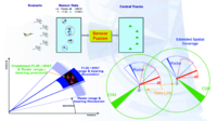
Cooperative vehicle positioning with multi-sensor data fusion and vehicular communications
Sign Up to like & getrecommendations! Published in 2019 at "Wireless Networks"
DOI: 10.1007/s11276-018-1772-6
Abstract: Vehicular positioning with multi-sensor fusion has achieved promising results in recent years. Having potential benefit from the emerging vehicular communications based on IEEE 802.11p dedicated short-range communication (DSRC), cooperative positioning opens new opportunities to support… read more here.
Keywords: vehicle; multi sensor; fusion; positioning multi ... See more keywords

Targets Classification Based on Multi-sensor Data Fusion and Supervised Learning for Surveillance Application
Sign Up to like & getrecommendations! Published in 2019 at "Wireless Personal Communications"
DOI: 10.1007/s11277-018-6114-6
Abstract: In surveillance application scenarios, like border security and area monitoring, potential targets to be detected may be either an unarmed person, a soldier carrying ferrous weapon or a vehicle. Detection is the first phase of… read more here.
Keywords: multi sensor; data fusion; fusion; surveillance application ... See more keywords

Mapping Mountain Peatlands and Wet Meadows Using Multi-Date, Multi-Sensor Remote Sensing in the Cordillera Blanca, Peru
Sign Up to like & getrecommendations! Published in 2019 at "Wetlands"
DOI: 10.1007/s13157-019-01134-1
Abstract: Wetlands (called bofedales in the Andes of Peru) are abundant and important components of many mountain ecosystems across the globe. They provide many benefits including water storage, high quality habitat, pasture, nutrient sinks and transformations,… read more here.
Keywords: multi; multi sensor; wet meadows; multi date ... See more keywords

In-situ multi-sensor characterization of soil cores along an erosion-deposition gradient
Sign Up to like & getrecommendations! Published in 2019 at "CATENA"
DOI: 10.1016/j.catena.2019.104140
Abstract: Abstract Soil landscape research is faced with wide-ranging questions of soil erosion, precision farming, and agricultural risk management. Digital Soil Morphometrics is a powerful tool to provide respective answers or recommendations but requires soil data… read more here.
Keywords: erosion deposition; multi sensor; soil;

Multi-sensor assessment of dynamic balance during gait in patients with subacute stroke.
Sign Up to like & getrecommendations! Published in 2017 at "Journal of biomechanics"
DOI: 10.1016/j.jbiomech.2017.07.034
Abstract: The capacity to maintain upright balance by minimising upper body oscillations during walking, also referred to as gait stability, has been associated with a decreased risk of fall. Although it is well known that fall… read more here.
Keywords: gait stability; subacute stroke; multi sensor; patients subacute ... See more keywords

Nonlinearity compensation of DIC-based multi-sensor measurement
Sign Up to like & getrecommendations! Published in 2018 at "Measurement"
DOI: 10.1016/j.measurement.2018.05.020
Abstract: Abstract The development of an efficient framework with an advanced algorithm for single or multi-sensors measurement using non-ADC (nADC) based direct interfacing circuits (DICs) is essential for better understanding of underlying phenomena. The major issue… read more here.
Keywords: measurement; multi sensor; sensor measurement; nonlinearity ... See more keywords

A novel improved full vector spectrum algorithm and its application in multi-sensor data fusion for hydraulic pumps
Sign Up to like & getrecommendations! Published in 2019 at "Measurement"
DOI: 10.1016/j.measurement.2018.10.011
Abstract: Abstract The full vector spectrum is an effective and efficient tool for homologous multi-sensor data fusion in rotating machinery. However, this methodology just takes Fourier Transform to obtain the harmonic trajectory information hidden in multi-sensor… read more here.
Keywords: full vector; fusion; vector; multi sensor ... See more keywords

Multi-sensor fusion method for roadheader pose detection
Sign Up to like & getrecommendations! Published in 2021 at "Mechatronics"
DOI: 10.1016/j.mechatronics.2021.102669
Abstract: Abstract Pose detection of roadheader has become an important topic in the field of mine automation. This paper presents a method of multi sensor data fusion for the detection of roadheader fuselage pose. The pose… read more here.
Keywords: detection; multi sensor; pose detection; fusion ... See more keywords

Multi-sensor measurement system for robotic drilling
Sign Up to like & getrecommendations! Published in 2017 at "Robotics and Computer-integrated Manufacturing"
DOI: 10.1016/j.rcim.2017.01.002
Abstract: In this paper we present a multi-sensor measurement system for robotic drilling. The system enables a robot to measure its 6D pose with respect to the work piece and to establish a reference coordinate system… read more here.
Keywords: system; sensor measurement; robotic drilling; multi sensor ... See more keywords

Multi-sensor assimilation of SMOS brightness temperature and GRACE terrestrial water storage observations for soil moisture and shallow groundwater estimation
Sign Up to like & getrecommendations! Published in 2019 at "Remote Sensing of Environment"
DOI: 10.1016/j.rse.2019.04.001
Abstract: Abstract The Gravity Recovery and Climate Experiment (GRACE) mission provided monthly global estimates of the vertically integrated terrestrial water storage with about 300–400-km horizontal resolution between 2002 and 2017. Since 2009, the Soil Moisture and… read more here.
Keywords: multi sensor; grace; assimilation; soil moisture ... See more keywords

Landslide mapping from multi-sensor data through improved change detection-based Markov random field
Sign Up to like & getrecommendations! Published in 2019 at "Remote Sensing of Environment"
DOI: 10.1016/j.rse.2019.111235
Abstract: Abstract Accurate landslide inventory mapping is essential for quantitative hazard and risk assessment. Although multi-temporal change detection techniques have contributed greatly to landslide inventory preparation, it is still challenging to generate quality change detection images… read more here.
Keywords: multi sensor; change; detection; change detection ... See more keywords